When will it snow next in the UK after Storm Goretti?

Parts of England were blanketed in heavy snow and ice after officials said it could be the “worst snowfall in a decade”.
Storm Goretti crossed the Channel towards the UK on Thursday evening and Friday, battering the Isles of Scilly and Cornwall with hurricane-force winds and blanketing much of the UK in snow.
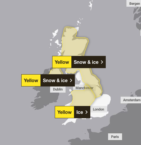
With people’s travel disrupted and schools closed, the Met Office issued a series of weather warnings for snow and ice across much of the country on Friday. There is also a yellow warning for rain across much of the east of England.
Storm Goretti is expected to slowly move away towards the end of Friday. But it won’t be long before the UK sees its next snowfall.
The Met Office’s three yellow snow and ice warnings have been extended until Saturday. Warnings cover Scotland and large parts of Northern England, the Midlands, parts of the South West, Wales and Northern Ireland.

The yellow warning for snow and ice will come into effect at noon on Friday and will be extended until 15:00 on Saturday. Further snowfall is likely across parts of northern England and much of Scotland, while the risk of widespread ice is expected to cause disruption.
A separate yellow warning for ice will cover large parts of England and Wales from midday on Friday until midday on Saturday as part-melt snow refreezes, accompanied by showers and freezing fog.
A yellow warning for snow and ice in Northern Ireland will come into force from 5pm on Friday and will remain in force until 11am on Saturday, with the Met Office warning of some snow in icy areas and hills.
A yellow weather warning for snow and ice has also been issued for Sunday in parts of Scotland, the north of England and the Midlands. The Met Office said parts of the affected area could see up to 30cm of snow, while 5cm could be seen over a wider area.
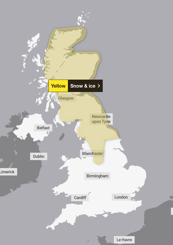
Forecasters say the snow band will move across the warning area on Sunday morning, with high ground once again seeing the heaviest snowfall.
Temperatures are expected to remain largely above freezing, around 2C, in most affected areas.
People are being asked to plan their travel routes in advance as the snow will bring “possible delays” that could leave people and cars stranded. The Met Office also told residents in affected areas to be prepared for potential power outages, saying this could also affect mobile phone coverage.
Met Office’s five-day weather forecast
Today
Storm Goretti will gradually move away but rain and some snow will continue in the east of England. Elsewhere, a mixture of clear and sunny weather with occasional showers. I feel windy and cold.

Tonight
Rain and sleet will gradually clear across the east of England, while showers will continue elsewhere, mostly along the coast. Another cold night with widespread frost and icing. The wind will ease towards the east.
Saturday
Light snowfall in parts of eastern England and Scotland. It is partly cloudy and variable clouds, it is unlikely that frost will occur in the inland areas during the day. The winds are much lighter than recently.
Outlook from Sunday to Tuesday
Wet and windy weather moving eastwards through Sunday, with some snowfall in the northern hills. There may also be wind here. It’s milder for everyone through Monday and Tuesday.


