More rain to hit UK this week as Met Office issues fresh weather warnings

Wetter weather is expected in the UK later in the week, with the Met Office issuing new weather warnings.
On Thursday, a yellow weather warning will come into force for London and South East England, South West England, Wales and the West Midlands from 5am and will remain in force until midnight.
Heavy rain on Wednesday night is expected to cause surface water overflow in some areas and disrupt transportation. The weather agency predicts that 10 to 20 mm of rain is likely to fall by the end of Thursday, with over 30 mm falling in a few spots.
A warning will be issued in Central, Tayside & Fife and the Grampian until midday on Thursday due to heavy rain and snowmelt causing disruption.
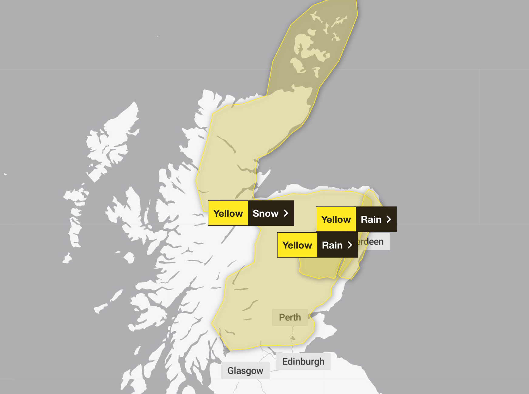
A warning for northern and eastern Scotland will be in force until 3pm on Wednesday as periods of sleet, snow and strong winds could lead to blizzard conditions.
The Met Office warned of dangerous driving conditions and said some roads and railways could be affected.
Snow accumulation of 1 to 3 cm is expected on the ground above 100 meters, and up to 5 cm in some areas. Precipitation at low levels will be snow, sleet and rain, which may lead to small snow accumulations in some areas.
This follows Storm Chandra, which brought record rainfall to parts of the UK.

Provisional Met Office statistics show Northern Ireland experienced its wettest January in 149 years, while southern England recorded its sixth wettest January since the series began in 1836.
Dr Amy Doherty, Met Office director of science, said: “January was an exceptionally wet month as we saw a very persistent pattern of weather in the Atlantic. A strong jet stream consistently directed low pressure systems towards the UK, bringing frequent rain and wind.
“With little opportunity for drier conditions in between, the ground became saturated, so even moderate rainfall had a greater impact. This succession of Atlantic systems is the main reason why this month’s rainfall totals are well above average for many regions.”

The Met Office’s five-day weather forecast is:
Today
Cloudy and rain will be limited to Northern England, Northern Ireland and Scotland, with snowfall likely in the higher hills. It’s drier further south, with some breaks in the clouds over the southern counties leading to some sunny weather. It’s not as cold as Tuesday.
Tonight
Cloudy skies once again prevail as the rain continues in Scotland and snow continues to fall in the eastern hills. More rain is falling south overnight as winds pick up for many.
Thursday
The rain is moving northwards throughout the day, becoming heavier in places, and snow is likely to fall again in north Wales, the Pennines and the Scottish Highlands. Rope that stays windy in the north. Average temperatures.
Outlook from Friday to Sunday
While the threat of winter continues in the northern half of the UK, it’s raining in the south. Saturday will be a little drier, but will remain mostly cloudy through the weekend.


